


DELMARVA - A developing low-pressure system moving through the Great Lakes will tug a warm front northward across Delmarva this weekend, resulting in unsettled weather for Sussex County’s beach towns and Ocean City, Maryland. From Saturday morning through early Monday, expect a mix of fog, showers, and temperature swings before a stronger cold front brings in a cooler and drier air mass to start the new week.
Saturday:
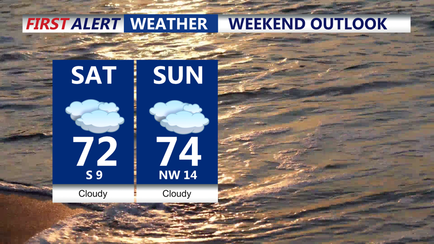
The day will begin damp and gray, with lingering fog and a cool onshore breeze keeping coastal temperatures in the upper 60s to low 70s. While steady rain is unlikely early on, occasional light showers and mist are possible throughout the day as the warm front struggles to lift northward. The farther south you are—particularly along the beaches—the more likely you’ll remain in the milder air, while inland areas may stay cooler and cloudier.
Saturday Night:
As the warm front nudges northward and moisture continues to stream in from the ocean, fog will become widespread overnight, potentially thickening across inland areas. Expect lows in the mid 50s to low 60s along the coast. A few isolated showers or even rumbles of thunder can't be ruled out, particularly toward the north and west.
Sunday:
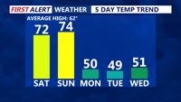
A stronger cold front approaches from the west, helping to break the fog and push showers into the region. Rain chances increase during the afternoon and evening, especially across central and northern Delmarva, though scattered rain could still affect coastal areas. Temperatures will vary widely depending on frontal position — beach towns may reach into the low to mid 70s, while areas to the north may linger in the 50s.
Some thunder is possible Sunday afternoon and evening, mainly along and south of the warm front, including southern Delmarva. However, no severe weather is expected.
Sunday Night into Early Monday:
A secondary wave of low pressure will form along the cold front, likely bringing another round of rain overnight into early Monday. This system may deliver up to an inch of rainfall, though totals will vary. As cooler air begins filtering in from the northwest, Monday morning will start off noticeably chillier and breezy, with morning lows dipping into the 40s.
Travel Tips & Reminders:
Foggy periods could impact travel visibility, particularly late Saturday into early Sunday.
Rain gear is recommended if you’re heading out Sunday afternoon or evening.
Watch for ponding on roads late Sunday night into Monday morning due to potential heavier rainfall.