


DELMARVA - Seasonably cool afternoon will feature partly cloudy skies with afternoon temperatures holding in the mid 40s before the next and stronger arctic front arrives later in the day.
By Friday evening a potent secondary arctic front will sweep through, ushering in dangerously cold air. Behind the front, winds are expected to increase, and temperatures will fall rapidly through Friday evening and into the overnight hours.
A Cold Weather Advisory is in effect for Friday night into early Saturday morning, with wind chills expected to drop below zero across the area. Even short periods outdoors could become uncomfortable and hazardous without proper protection, especially for anyone traveling late Friday night or starting their day early Saturday.
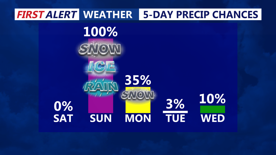
Saturday will remain bitterly cold, with increasing cloud cover and highs only in the low 20s, setting the stage for a significant winter storm expected to impact Delmarva beginning Saturday night.
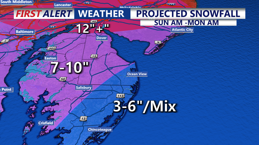
A major winter storm is forecast to move into the area Saturday night through early Monday afternoon, bringing significant impacts from accumulating snow, sleet and freezing rain. Precipitation is expected to spread into the region from southwest to northeast overnight Saturday night, beginning as all snow due to very cold air at the surface and throughout the atmosphere. As moisture deepens toward daybreak Sunday, snowfall may become moderate to heavy at times.
During the day Sunday, warmer air moving in aloft may create a “warm nose” in the atmosphere, allowing snow to mix with or change to sleet and freezing rain, especially across portions of the Eastern Shore and Mid-Shore of Maryland. Forecasters warn that sleet and freezing rain could reduce snow totals in some areas but create additional hazards, including slick travel and the potential for tree damage and power outages. Ice accretion over a quarter-inch is possible in parts of the Eastern Shore and Mid-Shore.
The Delmarva coast could also see a marine influence later Sunday, potentially causing precipitation to mix with or change to plain rain, though substantial snow is still expected before any changeover occurs.
Forecast snow totals currently range from 7 to 10 inches for much of the region, with mixing likely limiting totals in some areas. Along the Delaware coast and south toward Ocean City and Assateague, totals are projected around 3 to 6 inches.
As the storm begins to pull away Sunday night into early Monday, colder air is expected to filter back in, which may change precipitation back to all snow for most areas with additional accumulations possible.
A Winter Storm Watch remains in effect for the entire area from Saturday night through early Monday afternoon.
Stay up to date on the approaching winter storm with radar and hourly forecasts in the CoastTV weather app, available for Apple and Android.

