


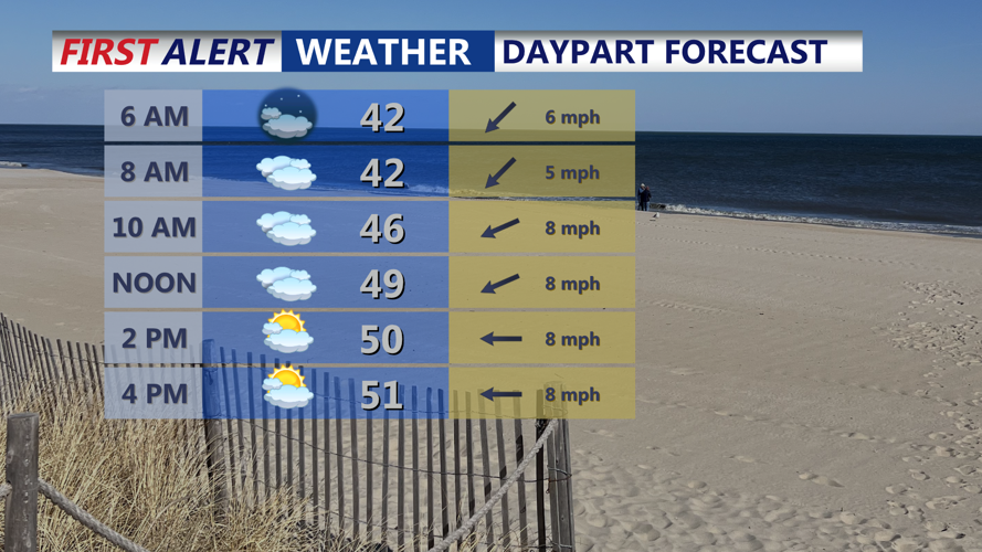


DELMARVA - A chilly and cloudy start to Friday is expected as high pressure remains in control. Onshore flow will keep low clouds and marine stratus lingering along the coast, with patchy drizzle possible in Delaware and Ocean City, Maryland. Morning temperatures will hover in the upper 30s to low 40s before climbing to the mid-to-upper 50s inland by afternoon. Coastal areas will remain cooler, with highs in the upper 40s to low 50s due to the ocean breeze.
By Friday afternoon, the high-pressure system will shift south, allowing some sunshine to break through for inland areas, while the beaches may remain under a blanket of low clouds. Winds will stay light but persistent from the east, reinforcing the cool coastal conditions.
SATURDAY WARMING TREND
Saturday will mark a shift toward milder temperatures as a warm front lifts north of the region. Morning fog and drizzle are likely, especially near the coast, but temperatures will climb into the 60s inland under partly cloudy skies. The beaches will stay slightly cooler, with highs in the upper 50s to near 60 degrees.
As the day progresses, increasing moisture and southerly winds will set the stage for a more unsettled pattern heading into Sunday. By Saturday night, fog and low clouds will thicken again, with overnight temperatures holding in the 50s—much milder than the previous nights.
LOOKING AHEAD: STRONG WINDS & STORMS SUNDAY NIGHT
Sunday will be the warmest day of the stretch, with highs in the upper 60s to low 70s, but a powerful cold front will bring a threat of heavy rain, strong winds, and even a few thunderstorms by Sunday night. Gusty winds could reach 40-50 mph, and brief street flooding is possible with heavier downpours.
By Monday, cooler and drier air will return, bringing more seasonable temperatures in the 50s.