


DELMARVA - Anticipate mostly cloudy skies with temperatures starting in the mid-40s. A warm front approaching the region brings a 50% chance of rain showers, especially in the late morning hours. Southwest winds will increase to 10 to 15 mph, with gusts up to 25 mph.
Afternoon: Overcast conditions persist, with temperatures peaking in the mid-60s. The chance of rain remains at 50%, with intermittent showers possible. Southwest winds continue at 10 to 15 mph, gusting up to 25 mph.
Evening: The likelihood of rain diminishes, with a 50% chance of showers early on. Skies are expected to gradually clear as the night progresses, and temperatures will drop to the upper 30s. Winds will shift to the west at 5 to 10 mph.
Friday:
Morning: Expect breezy and cooler conditions with sunny skies. Temperatures will start in the upper 30s, rising to a high of around 51°F by midday. West-northwest winds at 10 to 20 mph will make it feel cooler.
Afternoon: Sunshine will give way to increasing clouds as the day progresses. Temperatures will remain in the low 50s. Winds will persist from the west-northwest at 10 to 20 mph, gradually diminishing by evening.
Evening: Cloud cover increases, with temperatures dropping to the mid-30s overnight. Winds will shift to the south-southwest at 5 to 10 mph, signaling the approach of warmer air.
Saturday Early Morning:
- Pre-Dawn Hours: Anticipate cloudy and breezy conditions with temperatures rising from the mid-30s to the low 40s before sunrise. South-southwest winds will pick up, ranging from 15 to 25 mph, bringing warmer air into the region.
Marine and Beach Conditions:
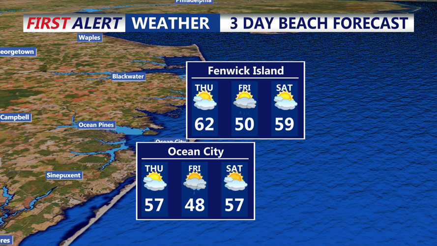
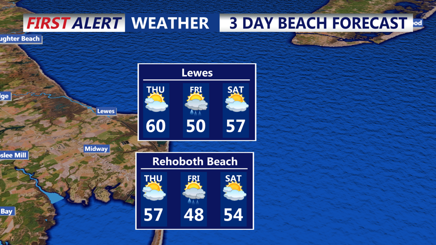
Thursday: Sea surface temperatures are currently around 40°F. Expect wave heights between 1.6 to 2.6 feet, with southwest winds at 10 to 15 mph, gusting up to 25 mph. These conditions may lead to choppy waters; exercise caution if planning marine activities.
Friday: Breezy conditions continue with west-northwest winds at 10 to 20 mph. Wave heights remain between 1.6 to 2.6 feet. Cooler air temperatures combined with cold sea surface temperatures may result in foggy conditions near the shore, potentially reducing visibility.
Saturday Early Morning: As winds shift to the south-southwest at 15 to 25 mph, wave heights may increase slightly. Warmer air moving over cooler waters could again lead to foggy conditions along the coast. Mariners and beachgoers should remain vigilant and check for any advisories before heading out.
Recent Weather Changes:
This period marks a transition from the milder conditions experienced earlier in the week to a brief cooler spell on Friday, followed by a return to milder weather as the weekend approaches. The passage of a warm front on Thursday brings initial mild temperatures and showers, while a subsequent cold front introduces cooler, breezy conditions on Friday. By early Saturday morning, the arrival of warmer air signals another shift, leading into a milder weekend.