


DELMARVA - A cold front moving through Sussex County and Delmarva’s Atlantic coast Wednesday will bring strong winds, rain, and snow showers, followed by colder air settling into the region overnight. By Thursday, conditions will stabilize briefly before another system arrives late in the day, bringing the possibility of wintry precipitation.
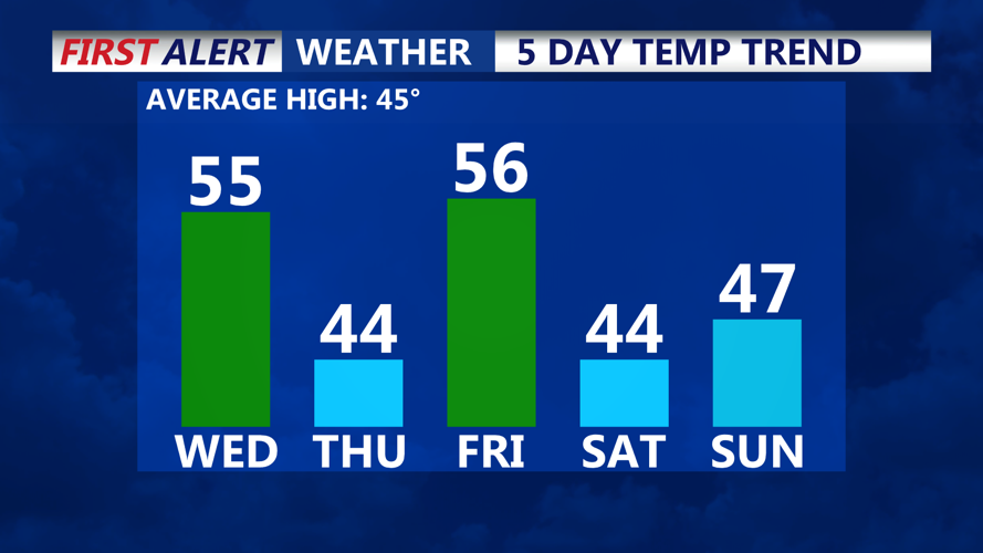
Wednesday morning will start with relatively tranquil conditions, but by midday, west winds will intensify, with gusts of 40 to 50 mph expected across the area. Temperatures will rise to the low- to mid-50s in southern Delaware and along Maryland’s Eastern Shore as warm air moves in ahead of the front.
As the front pushes through during the afternoon and evening, rain and snow showers are likely, with some areas experiencing squalls that may briefly reduce visibility. The strongest impacts are anticipated north of the Delmarva region.
Winds will diminish Wednesday night as the cold front exits and a fresh surge of Canadian air moves in. Overnight lows will drop below freezing, with most areas seeing temperatures in the 20s and some inland regions in the teens.
Thursday will bring partly sunny skies and colder conditions, with highs in the low 40s near the beaches and mid-30s further inland. By Thursday evening, clouds will increase ahead of an approaching low-pressure system.
Precipitation is expected to arrive late Thursday night, potentially beginning as a wintry mix before transitioning to rain as temperatures rise overnight. The timing and intensity of this system remain uncertain, but areas across Sussex County and the Ocean City region should monitor for possible icy conditions during the early stages of precipitation.
Residents should prepare for strong winds Wednesday, colder weather Thursday, and potential travel impacts Thursday night due to wintry precipitation.
