


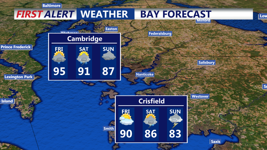


DELMARVA - Delmarva will continue to experience unsettled weather as an upper-level trough moves closer to the region. Morning temperatures will quickly rise into the upper 80s to low 90s, accompanied by high humidity. While a heat advisory is not anticipated at this time, the combination of heat and humidity will still be uncomfortable. Expect more showers and thunderstorms throughout the morning, with the potential for heavy rain.
Saturday Afternoon: The likelihood of showers and thunderstorms will persist into the afternoon. The high humidity and temperatures in the upper 80s to low 90s will continue. There is an increased risk of localized flooding due to heavy downpours, as well as the potential for damaging wind gusts from stronger storms. The Storm Prediction Center (SPC) has placed the area under a Marginal Risk (1 of 5) for severe weather and excessive rainfall.
Saturday Evening: Frequent showers and thunderstorms are expected to continue into Saturday evening. The lingering upper trough and weak surface systems will maintain high precipitable water levels and some shear, contributing to the potential for both heavy rains and severe weather. The SPC's Marginal Risk for severe weather remains in effect. Temperatures will remain warm, with highs in the mid to upper 80s, and moderate humidity levels.
Sunday Morning: The pattern of frequent showers and thunderstorms will persist into Sunday morning. Temperatures will be slightly cooler than Saturday, but still warm, with highs in the mid to upper 80s. Humidity will remain moderate, contributing to the overall muggy conditions. Heavy rain and localized flooding continue to be concerns.
Sunday Afternoon: Thunderstorms will remain likely throughout Sunday afternoon. The upper trough will still influence the region, keeping conditions unstable. Temperatures will stay in the mid to upper 80s with moderate humidity. The risk of severe weather decreases slightly, but the chance of heavy downpours and localized flooding persists.
Stay tuned to your local weather updates for the latest information and be prepared for rapidly changing weather conditions throughout the weekend.
