


DELMARVA - A stretch of warmer, springlike weather begins Thursday morning for Sussex County’s inland towns, beach communities, and Ocean City, as high pressure continues to shift offshore.
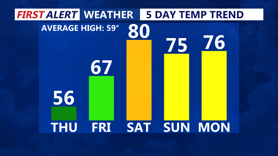
After a chilly overnight, Thursday will bring mostly sunny skies and seasonable highs in the mid to upper 50s inland, with slightly cooler temperatures along the coast. Winds will be lighter than Wednesday, generally west-northwest around 10 mph with occasional gusts near 20 mph.
Thursday night will be milder compared to recent nights, with lows ranging from the upper 30s inland to mid 40s near the water. Clouds will gradually increase overnight as a warm front approaches from the south.
Friday will feel noticeably warmer, especially away from the coast, as the warm front lifts through the region. Inland highs will climb into the low to mid 60s, while the ocean influence keeps coastal towns like Rehoboth Beach and Ocean City a bit cooler in the upper 50s. Skies will be partly to mostly cloudy, and while most of the day remains dry, scattered showers could begin moving in by Friday night.
The warm front may bring light, spotty rain overnight into early Saturday, though rainfall totals are expected to be minimal. Early Saturday morning lows will be relatively mild, in the mid 40s to low 50s.
Looking ahead to Saturday, the region is expected to remain on the warm side of the weather system, with highs pushing into the low 70s inland despite continued cloud cover and the chance of additional showers.