


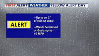
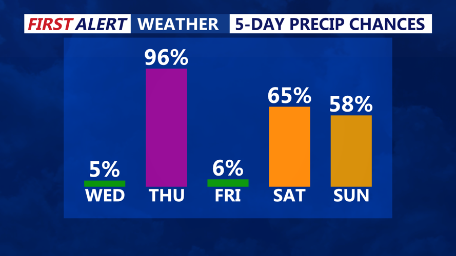
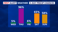

DELMARVA - Thursday will be a messy day across Sussex County as a low-pressure system tracks east, bringing a wintry mix of precipitation before tapering off to drizzle and mist in the afternoon. Early in the day, lingering snow and sleet will transition to freezing rain, with ice accumulation of up to two-tenths of an inch possible in inland areas. This will create treacherous road conditions for the morning commute, especially on untreated surfaces, overpasses, and bridges.
As temperatures rise above freezing, precipitation will change to rain by midday, but damp, cold air will keep conditions raw and dreary. The afternoon will feature misty, drizzly weather with light winds, limiting drying and allowing icy spots to persist in shaded areas and higher elevations. Highs will hover in the upper 30s inland, with mid-40s possible along the coast.
Thursday evening will bring a cold front sweeping through the region, though it will be largely moisture-starved. Any remaining showers should be light and scattered. Winds will gradually shift and pick up overnight, helping to dry out road surfaces, though temperatures will dip into the low 30s, raising concerns for refreezing in some spots.
By Friday, high pressure will briefly settle in, bringing a drier and breezy day. Skies will begin to clear, though a reinforcing dry cold front will push through, ushering in gusts of 20 to 30 mph by midday. While Friday will feel brisk, temperatures are expected to reach the low to mid-40s inland and could climb to the low 50s in southern Sussex County.
As winds diminish Friday night, temperatures will drop quickly into the 20s, setting the stage for another chilly night before the next storm system approaches for the weekend.